Satellite: The Earth Orbiting Object

There are nearly 4900 satellites orbiting the earth of which 1900 are active satellites. Where a satellite only has a lifespan of about 15 to 20 years, after that a satellite will not be active. The satellite orbits the planet Earth in a way around the earth in a geostationary orbit above the equator (0° latitude) which differs depending on the type of application or instrument used and remains in orbit due to a balance between gravity and centrifugal forces.
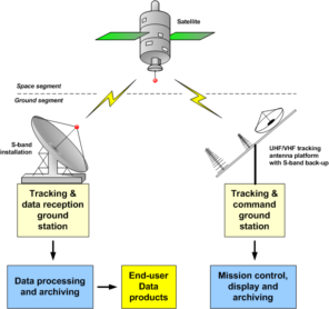 The beginning of the workings of a satellite begins with its launch from a station on earth to space carried by a carrier vehicle and launched by a rocket. Carrier vehicles and rockets will later fall back to earth after the satellite has arrived and is placed in temporary orbit. The rocket can only take the satellite to a temporary orbit, to get to the satellite’s permanent orbit using a motor placed in it. After the satellite arrives in geosynchronous orbit, the satellite is then taken over to be controlled through a system on the ground station. This control system is divided into two methods. The first is the Spin Stabilized Satellite method which works by moving parts of the satellite body to rotate in the desired direction.
Satellite divided into 2, namely natural satellites and artificial satellites. Natural satellites are satellites that come from nature such as the moon which is a natural satellite for the earth. Meanwhile, artificial satellites are human-made satellites for certain functions.

Types of Artificial Satellites:
1.Weather Satellite
Weather satellites are in charge of recording data on weather patterns that cover the earth. Many institutions use weather data from these satellites to perform weather forecasting, storm forecasting and others. Satellite exampleTIROS -1, Vanguard, NOAA-19, MetOp- A, Electro-L and Interbol.
2. Communication Satellite
Communications satellites act as relay stations in space and used as long-distance communication systems, such as telephone, internet, and data services. ExampleEcho 1 & 2, Relay 1 & 2, Express, Chinasat, Palapa A1 and Telkom -1.
3. Navigation Satellite
Navigation Satellite is a satellite system that provides independent geospatial positions with ordinary global coverage. These satellites are also referred to as GPS satellites which are used for sea, land and air navigation. For example IRNSS, GLONASS, Galileo, Michibiki and Beidou global.
4. Remote Sensing Satellite
Remote Sensing Satellites are specifically designed to observe Earth from orbits intended for non-military use. As for meteorology, maps, environmental monitoring, and others. ExampleLandsat Satellite, IKONOS and GeoEye.
5. Scientific Research Satellite
These satellites provide ground survey data, amateur radio, meteorological information, and various other scientific research applications.
6. Military Satellite
Satellites are used for military purposes such as satellite-based intelligence observations, navigation, and military communications. ExampleCanyon, Orion, Magnum and Spuntik.
")
Components of a telecommunications satellite:
1. Transponder
Transponder serves to change the frequency, eliminate noise and amplify the signal. A satellite has 20 or more transponders.
2. Power Supply
To run the transponder requires electrical power. On the satellite there is a power supply in the form of solar panels and batteries. Solar panels are used to provide power to electronic equipment. But when a solar eclipse occurs, it is the battery that provides power.
3. Solar Sensor
The solar sensor functions to adjust the solar panel towards the sun, so that it can extract maximum power.
4. Reflector Antenna
The reflector antenna is used to transmit the input signal to the transponder.
5. Thruster
Thruster serves to keep the satellite in the right position.
6. Fuel Tank
On the satellite there is a fuel tank that is useful for storing fuel in the form of Mono Methylhydrazine and Nitrogen tetraoxide.
")
Currently, Indonesia has launched 25 satellites, including:
1. Palapa-A1 Satellite
The Palapa-A1 satellite is Indonesia’s first satellite which was launched on July 8, 1976 with a capacity of 12 telephone transponders, 1 television transponder and 5 backup transponders.
2. Cakrawarta-2 Satellite (Indostar-2)
The Cakrawarta-2 (Indostar-2) satellite was launched on May 16, 2009 with a capacity of 22 Ku-Band transponders and 10 S-Band transponders.
3. Nusantara-1 Satellite
The Nusantara-1 satellite was launched on August 7, 2018 with a capacity of 22 C-Band transponders, 12 extended C-Band transponders, 8 Ku-Band transponders and is equipped with High Throughput Satellite (HTS) technology.
Currently, Indonesia is also in the process of making the Satria-1 Satellite (Satellite Indonesia Raya-1). This project was designed since 2016 and started with the signing of the Preparatory Work Agreement on 3 September 2020.
The satellite, which is planned to be operational in 2023, was created to support the needs of education, health, defense and security services as well as government, especially for disadvantaged areas. Just like the Nusantara-1 Satellite which is equipped with High Throughput Satellite (HTS) technology, this Satria-1 Satellite is also equipped with the same technology and with a Ka-Band frequency and a capacity of 150 gigabytes per second which can reach 150,000 public service points in remote areas that are not affordable fiber optic network.
Basically, satellite communications use the very high-frequency range of 1–50 gigahertz (GHz; 1 gigahertz = 1,000,000,000 hertz) to transmit and receive signals. The frequency ranges or bands are identified by letters: (in order from low to high frequency) L-, S-,C-, X-, My-, Ka-, and V-bands. Signals in the lower range (L-, S-, and C-bands) of the satellite frequency spectrum are transmitted with low power, and thus larger antennas are needed to receive these signals. Signals in the higher end (X-, Ku-, Ka-, and V-bands) of this spectrum have more power; therefore, dishes as small as 45 cm (18 inches) in diameter can receive them. This makes the Ku-band and Ka-band spectrum ideal for direct-to-home (DTH) broadcasting, broadband data communications, and mobile telephony and data applications.
In addition, the HTS technology used by the Nusantara-1 and Satria-1 satellites is a technology that functions to increase bandwidth capacity through frequency reuse. This means that each satellite dramatically increases bandwidth, and effectively delivers higher performance capabilities at a lower cost as the cost per bit drops as more bits of information can be transmitted simultaneously.
References
- https://ses-gs.com/solutions/fixed-sat-solutions/high-throughput-satellites/
- https://www.blog.calesmart.com/2017/05/26/656/
- https://www.baktikominfo.id/id/informasi/pengetahuan/cari_tahu_tentang_satelit_palapa_dan_keturunannya-656
- https://www.cnbcindonesia.com/news/20190224152921-4-57317/inilah-25-satelit-milik-indonesia-dari-waktu-ke-waktu
- https://www.un-spider.org/space-application/satellite-technology
- https://www.britannica.com/technology/satellite-communication/Satellite-applications
- https://www.nasa.gov/multimedia/imagegallery/image_feature_924.html